It seems that as the church age ends with the rapture, chaos and destruction will unfold upon the earth. This includes earthquakes, volcanic activity, terrors in the heavens, wars, and signs in the sun, moon, and stars. Today we are going to talk about Earthquakes and Volcanic Activity.
I strongly believe that there will be global earthquakes immediately before, during, and after the rapture of the church. I repeat, we may indeed see the *very beginning* part of these widespread earthquakes before we are transformed and snatched away from massive calamity. Do not lose hope in the rapture if an earthquake begins!
And I will show wonders in the heavens above and signs on the earth below, blood, and fire, and vapor of smoke; the sun shall be turned to darkness and the moon to blood, before the day of the Lord comes, the great and magnificent day. And it shall come to pass that everyone who calls upon the name of the Lord shall be saved.’ Acts 2:19-21 ESV
Now when these things begin to take place, straighten up and raise your heads, because your redemption is drawing near. Luke 21:28 ESV
After we have been taken safely up into heaven, these upcoming earthquakes will be so severe and widespread as to trigger volcanic eruptions and tsunamis. The volcanic ash in the atmosphere will lead to the famous global “Blood Moon Sign” of Joel 2 / Acts 2 / Revelation 6. These extreme global catastrophes will confuse the missing persons issue somewhat, and will certainly hinder the reporting of them.
Earthquake and Volcano Mini-Lesson
Let’s review what earthquakes and volcanoes are, what they can be caused by, and what their effects are. Pay attention to the parts I have bolded below for further discussion.
Wikipedia describes an earthquake:
An earthquake (also known as a quake, tremor or temblor) is the shaking of the surface of the Earth, resulting from the sudden release of energy in the Earth’s lithosphere that creates seismic waves. Earthquakes can range in size from those that are so weak that they cannot be felt to those violent enough to toss people around and destroy whole cities.
At the Earth’s surface, earthquakes manifest themselves by shaking and sometimes displacement of the ground. When the epicenter of a large earthquake is located offshore, the seabed may be displaced sufficiently to cause a tsunami. Earthquakes can also trigger landslides, and occasionally volcanic activity.
In its most general sense, the word earthquake is used to describe any seismic event — whether natural or caused by humans — that generates seismic waves. Earthquakes are caused mostly by rupture of geological faults, but also by other events such as volcanic activity, landslides, mine blasts, and nuclear tests.
https://en.wikipedia.org/wiki/Earthquake
Wikipedia describes a volcano:
A volcano is a rupture in the crust of a planetary-mass object, such as Earth, that allows hot lava, volcanic ash, and gases to escape from a magma chamber below the surface.
Earth’s volcanoes occur because its crust is broken into 17 major, rigid tectonic plates that float on a hotter, softer layer in its mantle. Therefore, on Earth, volcanoes are generally found where tectonic plates are diverging or converging, and most are found underwater.
Erupting volcanoes can pose many hazards, not only in the immediate vicinity of the eruption. Large eruptions can affect temperature as ash and droplets of sulfuric acid obscure the sun and cool the Earth’s lower atmosphere (or troposphere); however, they also absorb heat radiated from the Earth, thereby warming the upper atmosphere (or stratosphere). Historically, volcanic winters have caused catastrophic famines.
https://en.wikipedia.org/wiki/Volcano
The Earthquake Resurrection Pattern
Ok, so we have earthquakes resulting from the sudden release of energy. Normally, they are the result of the rupture of fault lines, but did you notice that they can be generated via nuclear explosions? This reminds me of the earthquake resurrection pattern seen in scripture. A great earthquake occurred at the resurrection of Jesus and the “many saints” as the firstfruits of the first resurrection. In the future, there will be a great earthquake when the 2 witnesses are resurrected from the dead. We are told in Ephesians 1:19-20 that great power is released when individuals are resurrected to immortality – “and what is the immeasurable greatness of his power toward us who believe, according to the working of his great might that he worked in Christ when he raised him from the dead and seated him at his right hand in the heavenly places”. (ESV)
The main harvest of the first resurrection will occur at the resurrection/rapture of the dead and alive in Christ immediately prior to the “Time of Jacob’s Trouble”. This upcoming “rapture” will be the largest nuclear event ever to unfold upon the earth. I believe it will be the cause global, severe earthquakes. These earthquakes will likely be most severe in places where there are many dead and alive in Christ. More on this can be found here: The Noisy, Not-So-Secret Rapture of the Church.
These resurrection earthquakes will trigger tsunamis and volcanic eruptions on a global scale. The global ash cover from the volcanoes will be the source of the darkened sun and “blood moon” signs. The ash will also likely cause temperature fluctuations around the world and trigger catastrophic famines. If Seals 3, 4, and 6 aren’t coming to your mind right now, they should be….
Tracking Earthquakes and Volcanic Activity Globally
I have been tracking earthquake and volcanic activity globally for a while now. While we may or may not see an increase in activity in the time leading up to the rapture, we most certainly will immediately preceding and during the rapture. Whether or not it will have time and ability to be recorded and broadcast, I’m not sure.
This is a picture of the major fault lines on the earth. I try to relate current earthquakes to their locations on the fault lines:
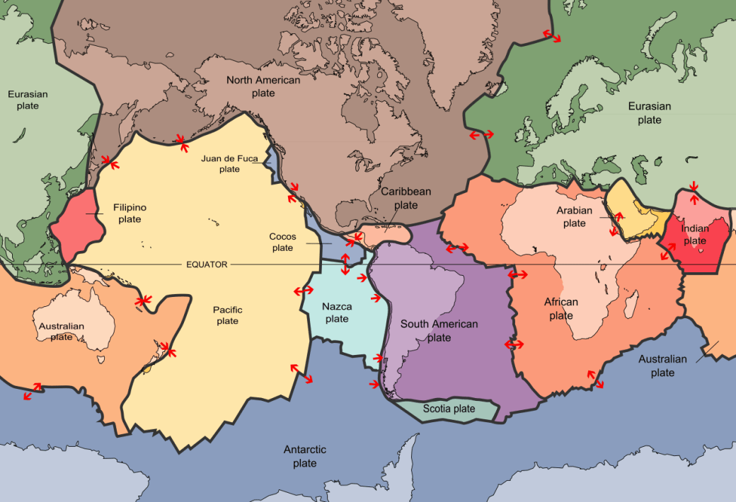
Tectonic Plates of the World: http://pubs.usgs.gov/publications/text/slabs.html
The most active fault lines are located along the “Ring of Fire”:
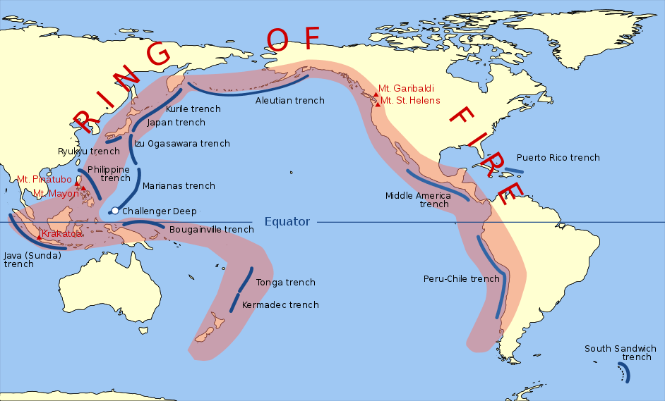
Pacific Ring of Fire: https://en.wikipedia.org/wiki/Ring_of_Fire#/media/File:Pacific_Ring_of_Fire.svg
Wikipedia describes the Ring of Fire:
The Ring of Fire is a major area in the basin of the Pacific Ocean where a large number of earthquakes and volcanic eruptions occur. In a 40,000 km (25,000 mi) horseshoe shape, it is associated with a nearly continuous series of oceanic trenches, volcanic arcs, and volcanic belts and plate movements. It has 452 volcanoes (more than 75% of the world’s active and dormant volcanoes).
About 90% of the world’s earthquakes and 81% of the world’s largest earthquakes occur along the Ring of Fire. The next most seismically active region (5–6% of earthquakes and 17% of the world’s largest earthquakes) is the Alpide belt, which extends from Java to the northern Atlantic Ocean via the Himalayas and southern Europe. All but three of the world’s 25 largest volcanic eruptions of the last 11,700 years occurred at volcanoes in the Ring of Fire.
https://en.wikipedia.org/wiki/Ring_of_Fire
The sites I use to track Earthquake and Volcanic activity are:
- The European-Mediterranean Seismological Centre – https://www.emsc.eu/#2
- USGS Earthquake Hazards Program – https://earthquake.usgs.gov/
- Earth Alerts – http://earthalerts.manyjourneys.com/web/
- Earthquakes Tracker (app)
What Have Earthquakes Been Doing Lately?
We are right on track with global earthquake averages over the last 28 years. There has been no recent uptick, as of March 2018. On average, over the last 28 years, there have been:
- 8.0+ – one yearly
- 7.0 – 7.9 – 14 yearly (approximately one a month)
- 6.0 – 6.9 – 140 yearly (approximately 2-3 a week)
- 5.0 – 5.9 – 1400 yearly (lots)
The number of deaths varies dramatically according to the proximity of the earthquake’s epicenter to densely populated areas. You can look through these stats for yourself here: https://earthquake.usgs.gov/earthquakes/browse/stats.php.
The Cascadia Subduction Zone:
While the Ring of Fire experiences many minor and moderate earthquakes as the tectonic plates slip over top of one another, there is one major plate that is wedged tight and unable to release minor pressures. This fault line is known as the Cascadia Subduction Zone, and it runs along the entire west coast of Canada and the USA. This is the big one, folks. This is the one that I believe will relieve its’ pressure either immediately before, during, or after the resurrection/rapture event.
Let’s examine this massive earthquake-in-waiting. Bolding from the below articles is mine:
The Giant Underestimated Earthquake Threat to North America – March 13, 2012 – Discover Magazine.
Just over one year ago, a magnitude-9 earthquake hit the Tohoku region of northeastern Japan, triggering one of the most destructive tsunamis in a thousand years. The Japanese—the most earthquake-prepared, seismically savvy people on the planet—were caught off-guard by the Tohoku quake’s savage power. Over 15,000 people died.
Now scientists are calling attention to a dangerous area on the opposite side of the Ring of Fire, the Cascadia Subduction Zone, a fault that runs parallel to the Pacific coast of North America, from northern California to Vancouver Island. This tectonic time bomb is alarmingly similar to Tohoku, capable of generating a megathrust earthquake at or above magnitude 9, and about as close to Portland, Seattle, and Vancouver as the Tohoku fault is to Japan’s coast. Decades of geological sleuthing recently established that although it appears quiet, this fault has ripped open again and again, sending vast earthquakes throughout the Pacific Northwest and tsunamis that reach across the Pacific.
What happened in Japan will probably happen in North America. The big question is when.
Source: http://discovermagazine.com/2012/extreme-earth/01-big-one-earthquake-could-devastate-pacific-northwest
The Really Big One – July 20, 2015 – Annals of Seismology
Most people in the United States know just one fault line by name: the San Andreas, which runs nearly the length of California and is perpetually rumored to be on the verge of unleashing “the big one.” That rumor is misleading, no matter what the San Andreas ever does. Every fault line has an upper limit to its potency, determined by its length and width, and by how far it can slip. For the San Andreas, one of the most extensively studied and best understood fault lines in the world, that upper limit is roughly an 8.2—a powerful earthquake, but, because the Richter scale is logarithmic, only six per cent as strong as the 2011 event in Japan.
Just north of the San Andreas, however, lies another fault line. Known as the Cascadia subduction zone, it runs for seven hundred miles off the coast of the Pacific Northwest, beginning near Cape Mendocino, California, continuing along Oregon and Washington, and terminating around Vancouver Island, Canada.
Take your hands and hold them palms down, middle fingertips touching. Your right hand represents the North American tectonic plate, which bears on its back, among other things, our entire continent, from One World Trade Center to the Space Needle, in Seattle. Your left hand represents an oceanic plate called Juan de Fuca, ninety thousand square miles in size. The place where they meet is the Cascadia subduction zone. Now slide your left hand under your right one. That is what the Juan de Fuca plate is doing: slipping steadily beneath North America. When you try it, your right hand will slide up your left arm, as if you were pushing up your sleeve. That is what North America is not doing. It is stuck, wedged tight against the surface of the other plate.
Without moving your hands, curl your right knuckles up, so that they point toward the ceiling. Under pressure from Juan de Fuca, the stuck edge of North America is bulging upward and compressing eastward, at the rate of, respectively, three to four millimetres and thirty to forty millimetres a year. It can do so for quite some time, because, as continent stuff goes, it is young, made of rock that is still relatively elastic. (Rocks, like us, get stiffer as they age.) But it cannot do so indefinitely. There is a backstop—the craton, that ancient unbudgeable mass at the center of the continent—and, sooner or later, North America will rebound like a spring. If, on that occasion, only the southern part of the Cascadia subduction zone gives way—your first two fingers, say—the magnitude of the resulting quake will be somewhere between 8.0 and 8.6. That’s the big one. If the entire zone gives way at once, an event that seismologists call a full-margin rupture, the magnitude will be somewhere between 8.7 and 9.2. That’s the very big one.
Flick your right fingers outward, forcefully, so that your hand flattens back down again. When the next very big earthquake hits, the northwest edge of the continent, from California to Canada and the continental shelf to the Cascades, will drop by as much as six feet and rebound thirty to a hundred feet to the west—losing, within minutes, all the elevation and compression it has gained over centuries. Some of that shift will take place beneath the ocean, displacing a colossal quantity of seawater. (Watch what your fingertips do when you flatten your hand.) The water will surge upward into a huge hill, then promptly collapse. One side will rush west, toward Japan. The other side will rush east, in a seven-hundred-mile liquid wall that will reach the Northwest coast, on average, fifteen minutes after the earthquake begins. By the time the shaking has ceased and the tsunami has receded, the region will be unrecognizable. Kenneth Murphy, who directs fema’s Region X, the division responsible for Oregon, Washington, Idaho, and Alaska, says, “Our operating assumption is that everything west of Interstate 5 will be toast.”
fema projects that nearly thirteen thousand people will die in the Cascadia earthquake and tsunami. Another twenty-seven thousand will be injured, and the agency expects that it will need to provide shelter for a million displaced people, and food and water for another two and a half million.
We now know that the Pacific Northwest has experienced forty-one subduction-zone earthquakes in the past ten thousand years. If you divide ten thousand by forty-one, you get two hundred and forty-three, which is Cascadia’s recurrence interval: the average amount of time that elapses between earthquakes. That timespan is dangerous both because it is too long—long enough for us to unwittingly build an entire civilization on top of our continent’s worst fault line—and because it is not long enough. Counting from the earthquake of 1700, we are now three hundred and fifteen years into a two-hundred-and-forty-three-year cycle.
The first sign that the Cascadia earthquake has begun will be a compressional wave, radiating outward from the fault line. Compressional waves are fast-moving, high-frequency waves, audible to dogs and certain other animals but experienced by humans only as a sudden jolt. They are not very harmful, but they are potentially very useful, since they travel fast enough to be detected by sensors thirty to ninety seconds ahead of other seismic waves. That is enough time for earthquake early-warning systems, such as those in use throughout Japan, to automatically perform a variety of lifesaving functions: shutting down railways and power plants, opening elevators and firehouse doors, alerting hospitals to halt surgeries, and triggering alarms so that the general public can take cover. The Pacific Northwest has no early-warning system. When the Cascadia earthquake begins, there will be, instead, a cacophony of barking dogs and a long, suspended, what-was-that moment before the surface waves arrive. Surface waves are slower, lower-frequency waves that move the ground both up and down and side to side: the shaking, starting in earnest.
Soon after that shaking begins, the electrical grid will fail, likely everywhere west of the Cascades and possibly well beyond. If it happens at night, the ensuing catastrophe will unfold in darkness. In theory, those who are at home when it hits should be safest; it is easy and relatively inexpensive to seismically safeguard a private dwelling. But, lulled into nonchalance by their seemingly benign environment, most people in the Pacific Northwest have not done so. That nonchalance will shatter instantly. So will everything made of glass. Anything indoors and unsecured will lurch across the floor or come crashing down: bookshelves, lamps, computers, cannisters of flour in the pantry. Refrigerators will walk out of kitchens, unplugging themselves and toppling over. Water heaters will fall and smash interior gas lines. Houses that are not bolted to their foundations will slide off—or, rather, they will stay put, obeying inertia, while the foundations, together with the rest of the Northwest, jolt westward. Unmoored on the undulating ground, the homes will begin to collapse.
Across the region, other, larger structures will also start to fail.
The shaking from the Cascadia quake will set off landslides throughout the region—up to thirty thousand of them in Seattle alone, the city’s emergency-management office estimates. It will also induce a process called liquefaction, whereby seemingly solid ground starts behaving like a liquid, to the detriment of anything on top of it.
Together, the sloshing, sliding, and shaking will trigger fires, flooding, pipe failures, dam breaches, and hazardous-material spills. Any one of these second-order disasters could swamp the original earthquake in terms of cost, damage, or casualties—and one of them definitely will. Four to six minutes after the dogs start barking, the shaking will subside. For another few minutes, the region, upended, will continue to fall apart on its own. Then the wave will arrive, and the real destruction will begin.
Among natural disasters, tsunamis may be the closest to being completely unsurvivable. The only likely way to outlive one is not to be there when it happens: to steer clear of the vulnerable area in the first place, or get yourself to high ground as fast as possible. For the seventy-one thousand people who live in Cascadia’s inundation zone, that will mean evacuating in the narrow window after one disaster ends and before another begins. They will be notified to do so only by the earthquake itself—“a vibrate-alert system,” Kevin Cupples, the city planner for the town of Seaside, Oregon, jokes—and they are urged to leave on foot, since the earthquake will render roads impassable. Depending on location, they will have between ten and thirty minutes to get out. That time line does not allow for finding a flashlight, tending to an earthquake injury, hesitating amid the ruins of a home, searching for loved ones, or being a Good Samaritan.
Those who cannot get out of the inundation zone under their own power will quickly be overtaken by a greater one. A grown man is knocked over by ankle-deep water moving at 6.7 miles an hour. The tsunami will be moving more than twice that fast when it arrives. Its height will vary with the contours of the coast, from twenty feet to more than a hundred feet. It will not look like a Hokusai-style wave, rising up from the surface of the sea and breaking from above. It will look like the whole ocean, elevated, overtaking land. Nor will it be made only of water—not once it reaches the shore. It will be a five-story deluge of pickup trucks and doorframes and cinder blocks and fishing boats and utility poles and everything else that once constituted the coastal towns of the Pacific Northwest.
osspac estimates that in the I-5 corridor it will take between one and three months after the earthquake to restore electricity, a month to a year to restore drinking water and sewer service, six months to a year to restore major highways, and eighteen months to restore health-care facilities. On the coast, those numbers go up. Whoever chooses or has no choice but to stay there will spend three to six months without electricity, one to three years without drinking water and sewage systems, and three or more years without hospitals. Those estimates do not apply to the tsunami-inundation zone, which will remain all but uninhabitable for years.
Source: https://www.newyorker.com/magazine/2015/07/20/the-really-big-one
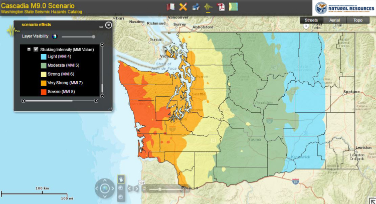
DNR Mapping Tool Shows Hazards You Might Face in Cascadia Event:
The Yellowstone Supervolcano
As I mentioned above, I believe that the global earthquakes (likely involving the Cascadia Subduction Zone) triggered at the resurrection/rapture event will also trigger volcanic eruptions. While these also will be global, the one I am particularly watching is the Yellowstone Supervolcano. This is the one that will likely be a major contributing factor to the global ash cloud, which in turn will wreak havoc on global climate and food production. It will also cause the darkened sun and “blood moon” described in Revelation chapter 6.
Let’s examine this supervolcano, bolding is mine:
Modeling the Ash Distribution of a Yellowstone Supereruption
August 27, 2014
The topic of Yellowstone supereruptions (ones producing greater than one thousand cubic kilometers of volcanic debris) generates much interest, but also occasional confusion. New computer models can help clarify the reality of eruption impacts, and provide insight on past eruptions.
Supereruptions distribute ash in a fundamentally different pattern than smaller eruptions by creating an umbrella cloud that can push ash more than a thousand kilometers upwind. The mapped pattern of ash deposition from weaker eruptions looks roughly like a fan, spreading downwind from the volcano; while that from a supereruption looks more like a bull’s eye, centered on the volcano. A powerfully spreading umbrella cloud means that ash dispersal is much less affected by atmospheric winds.
Is there any evidence that Yellowstone will erupt soon?
No. Yellowstone is behaving as it has for the past 140 years. And geological evidence indicates that similar or higher rates of earthquakes, ground uplift and steam explosions were experienced at Yellowstone over much of the past ~10,000 years. Odds are very high that Yellowstone will be eruption- free for the coming centuries.
If Yellowstone erupts, will it be the “big one” modeled in this recent article?
Almost certainly not. The past 20 eruptions at Yellowstone have been lava flows with no significant amounts of ash fall outside of Yellowstone. The past 60-80 eruptions would have had little regional (or continental) impact.
How will you know if an eruption is beginning?
Yellowstone hasn’t erupted for 70,000 years, so it’s going to take some impressive earthquakes and ground uplift to get things started. Besides intense earthquake swarms (with many earthquakes above M4 or M5) we expect rapid and notable uplift around the caldera (possibly tens of inches per year). Finally, rising magma will cause explosions from the boiling-temperature geothermal reservoirs. Even with explosions, earthquakes, and notable ground uplift, the most likely volcanic eruptions would be the type that would have minimal affect outside the park itself.
Source: https://volcanoes.usgs.gov/volcanoes/yellowstone/faqs_ash3d.html


Yellowstone Eruption Imminent: Supervolcano Anomaly Triggers Fears of Volcano to Blow: Sebastian Kettley March 22, 2018
YELLOWSTONE volcano could be on the brink of cataclysmic eruption after a pair of researchers uncovered a magma “anomaly” stretching across the country under the deadly super volcano.
The two volcano researchers uncovered evidence of a plume “abnormality” underneath the volcano, in between the Earth’s core and mantle, which could run all the way to Mexico.
The findings of their research were published in the scientific journal Nature Geoscience and have already taken over the imagination of the public.
Lower-mantle plume beneath the Yellowstone hotspot revealed by core waves
Abstract: The Yellowstone hotspot, located in North America, is an intraplate source of magmatism the cause of which is hotly debated. Some argue that a deep mantle plume sourced at the base of the mantle supplies the heat beneath Yellowstone, whereas others claim shallower subduction or lithospheric-related processes can explain the anomalous magmatism. Here we present a shear wave tomography model for the deep mantle beneath the western United States that was made using the travel times of core waves recorded by the dense USArray seismic network. The model reveals a single narrow, cylindrically shaped slow anomaly, approximately 350 km in diameter that we interpret as a whole-mantle plume. The anomaly is tilted to the northeast and extends from the core–mantle boundary to the surficial position of the Yellowstone hotspot. The structure gradually decreases in strength from the deepest mantle towards the surface and if it is purely a thermal anomaly this implies an initial excess temperature of 650 to 850 °C. Our results strongly support a deep origin for the Yellowstone hotspot, and also provide evidence for the existence of thin thermal mantle plumes that are currently beyond the resolution of global tomography models.
Article here: https://www.nature.com/articles/s41561-018-0075-y
Is America In Biblical Prophecy?
So many people search to find America in Bible Prophecy. They relate any passages containing the word “eagle” to themselves, and develop theories on how America might come into play.
I don’t believe America will play a part in Bible Prophecy past the rapture of the church. It’s not in there, because I believe it will abruptly cease to be a major world player. And the cause of this will be the resurrection/rapture event, the Cascadia Subduction Zone full-margin rupture, resultant tsunamis, and the eruption of the Yellowstone Supervolcano. Together, these will so cripple the USA (and Canada), that they will never recover. Some individuals may survive, but it will be harsh with limited-to-no electricity, food, or clean water sources. On top of this, the effects of the Seals, Trumpets, and Bowls will be occurring as God pours out His judgment upon the earth. The impact to the nation is incomprehensible.
An Escape Plan
Note that both Jesus and Paul mention there is a way to obtain salvation – to escape all these things that are going to take place on the earth.
For God has not destined us for wrath, but to obtain salvation through our Lord Jesus Christ, who died for us so that whether we are awake or asleep we might live with him. Therefore encourage one another and build one another up, just as you are doing. 1 Thessalonians 5:9-11 ESV
“Pray that you may have strength to escape all these things and STAND before the Son of Man.” Luke 21:36 ESV
There is no where on EARTH to escape, but the true body of Christ will escape. Right after Seal 6 is opened, we see a large group of people from every tribe, language, people, and nation STANDING in front of the throne and the Lamb (Rev 7:9) and singing about salvation. WE, the saved by grace through faith in Jesus Christ, will stand. “And it shall come to pass that everyone who calls upon the name of the Lord shall be saved”, right on time, BEFORE the Day of the Lord.
For Further Reading:
Are you CERTAIN of your Salvation, beyond a shadow of a doubt? Do you KNOW that no matter when the rapture occurs, you will be counted worthy to escape? If not, please read What Must I do to Be Saved.
The Rapture of the Church – Our Blessed Hope
Who Is Worthy to Escape All These Things?
The Noisy, Not-So-Secret Rapture of the Church
I have detailed signs in the sun, moon, and stars, terrors in the heavens, and upcoming prophetic wars here:
- The Blood Moon Sign
- The Blood Moon – Seal 6
- Overview of Coming Prophetic Wars
- Nation Rising Against Nation, Kingdom Rising Against Kingdom – WW3
- The Gog and Magog War of Ezekiel 38 & 39
- Ezekiel 38-39 Verse by Verse Discussion
- Connecting Isaiah 17, Psalm 83, Ezekiel 38&39
- Revelation 12 – A Sign in the Heavens, September 23, 2017
- Where is the Dragon? Examining Revelation 12:3-4
- Is Planet X the Dragon of Revelation 12?
A fun, factual mini-introduction to these topics on YouTube is with Dr. Binocs:
- Earthquakes: https://www.youtube.com/watch?v=dJpIU1rSOFY
- Volcanoes: https://www.youtube.com/watch?v=lAmqsMQG3RM
- Tsunamis: https://www.youtube.com/watch?v=MfsugkikLJI
- Richter Scale: https://www.youtube.com/watch?v=u-QbqGB1Ooc
For those Left Behind – Be Prepared: Volcanic Ash Fall
God’s Mosaic – A Whole Scripture Overview of Things To Come
Main Menu – God’s Mosaic Prophecy Model
The Bible is infallible. I am not. I am merely challenging traditional models and testing them against Scripture. I believe that traditional pretribulation teachings provide a solid backbone upon which to lay the musculature of details. I encourage you to consider my thoughts as you also examine the scriptures to see if these things are so!
